Google Maps
Gain geo AI insights with Google Maps Platform
Turn location data into geo AI with Insight’s Google Maps services so you can plan smarter, move faster, and build better customer experiences at scale.
What is geo AI?
Google's geospatial artificial intelligence (geo AI) fuses Google Maps Platform data with next-gen artificial intelligence. By grounding Gemini’s reasoning in real-world Maps, Routes, and Places data, this technology allows businesses to turn geographical context into trusted, AI-first experiences.
Put Google Maps Platform to work for your organization with geo AI.
Analytics
Combine Google Maps data with your own in BigQuery to analyze over 250 million places and unlock insights from AI-powered imagery.
Maps
Create immersive location-aware experiences that improve relevance, engagement, and conversion.
Routes
Help clients get to you — and your teams get where they need to go — with optimized routing, real-time traffic updates, and precise ETAs.
Places
Streamline operations. Improve address accuracy, speed up checkout, and validate locations using trusted place and autocomplete data.
Environment
Support sustainability and resilience with geospatial insights for weather awareness, infrastructure planning, and risk reduction.

Work with a premier Google Maps Platform partner.
Insight has helped clients integrate Google Maps since 2013. We combine geo AI expertise with partner advantages to help you optimize usage, reduce cost, and scale faster.
- Pricing advantages with volume discounts, simplified billing, and flexible procurement terms
- Google Cloud Advanced Competency in Geo (Location-Based Services)
- Trusted by 600+ organizations to build and scale Google Maps Platform
- Google Cloud 2024 Specialization Partner of the Year for Location-Based Services
How Insight and Google Maps helped chart a better path
Geo AI is especially valuable in location-specific industries such as real estate, hospitality, retail, eCommerce, insurance, and logistics. See how Insight helped Cotality (formerly CoreLogic) embed Google Maps Platform into its real estate portal to improve customer satisfaction.
“If you need to innovate, grow, and execute in a timely fashion, by all means, choose Insight for Google Maps."
Sunny Ramamurthy,
Director of Product Management, Real Estate Solutions, at CoreLogic

Read the client story
What’s new in
Google Maps Platform?
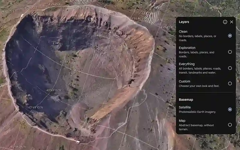
Google Earth Professional
Google Earth Pro brings together high-resolution imagery, 3D environments, and GIS data layers so teams can visualize, analyze, and share real-world insights in one place.
Google Earth Professional Advanced
Gain deeper geospatial analysis with specialized, AI-powered data layers (e.g., EV infrastructure, zoning, traffic) to support faster, enterprise-scale decision-making.
Places Insights
Bring the power of Google Maps data to BigQuery. Seamlessly analyze insights from over 250M+ places to evaluate markets, site locations, and competitive landscapes.
Imagery Insights
Imagery Insights transforms 280B+ Street View images into structured data in BigQuery. Using Gemini Enterprise Agent Platform, teams can automate asset detection and infrastructure analysis — completely eliminating costly field surveys.
Still have questions about Google Maps Platform? We have answers.
Get more value from your Google Maps Platform investment.
Tell us your use case and we’ll help you design the right solution, optimize cost, and scale faster with Google Maps. Insight is trusted by 600+ organizations to build and scale Google Maps Platform.
"Customers should expect they are working with a partner that has over a decade of Google Maps experience and understands how to deliver a solution that leverages best-in-class mapping technology from Google."

Doug Daniels
Director of Location Intelligence, Insight